
Flood Extent Detection
Overview
Flood extent is difficult to acquire as a true in situ reference because it is hazardous to operate in a flood zone, and physical access to the flood via roads, etc. are also equally hazardous and limited. Being able to detect flood extent provides automated ways to assist disaster response during flood events.
This competition seeks to develop approaches to delineate open water flood areas, helping to identify flood extent, an impactful disaster that occurs frequently throughout the world. The competition will involve a supervised learning task - participants will develop algorithms to identify flood pixels after training their algorithm against a training set of synthetic aperture radar (SAR) images.
Sample images and ground truth used for competition are shown in Fig. 1.
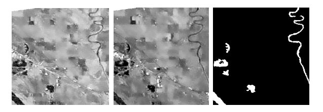
Fig 1 SAR image tiles with flooded areas. Left: VH Channel, Middle: VV Channel, Right: Classification Bitmap
More detailed information can be found at the challenge webpage. Please submit your solutions to the challenge codalab page.
Organizers
Dr. Manil Maskey leads various projects at the National Aeronautics and Space Administration (NASA) Marshall Space Flight Center (MSFC) and Earth Science Data Systems (ESDS) Program at NASA Headquarters. Currently, Dr. Maskey is developing artificial intelligence and machine learning strategic roadmap for the ESDS program. At MSFC, he leads the advanced concepts team for the Inter-Agency Implementation and Advanced Concepts (IMPACT) project, where he develops innovative data-driven solutions to challenging Earth science problems. Dr. Maskey is also leading Science Mission Directorate’s AIML projects as part of the open science data initiative. Dr. Maskey's career spans over 20 years in academia, industry, and government. During that time, he has focused on research and application projects in the area of data systems, machine learning, computer vision, and visualization.
Iksha Gurung is a Computer Scientist working with University of Alabama in Huntsville supporting the National Aeronautics and Space Administration Interagency Implementation of Advanced Concepts Team (NASA-IMPACT). He leads the development and machine learning team in NASA-IMPACT.
Muthukumaran Ramasubramanian is a Computer Scientist specializing in Machine Learning working with University of Alabama in Huntsville, supporting National Aeronautics and Space Administration Interagency Implementation of Advanced Concepts Team (NASA-IMPACT). He wrangles data and trains machine learning models to detect/extract features from remote sensing data.
This competition is organized by the NASA Interagency Implementation and Advanced Concepts Team in collaboration with the IEEE GRSS Earth Science Informatics Technical Committee.